
Anúncios
Earthquakes strike without warning, and in those critical seconds, every moment counts. Modern technology now offers a lifeline through specialized apps designed to detect seismic activity and alert users before disaster strikes.


Living in seismically active regions means constantly balancing awareness with daily life. While we cannot predict exactly when an earthquake will occur, technology has evolved to provide precious seconds of warning that can mean the difference between safety and danger. Earthquake detection apps have transformed smartphones into personal seismometers, connecting millions of users to real-time geological data.
Anúncios
These innovative applications leverage accelerometers built into modern smartphones, combined with data from official seismological networks worldwide. The result is a crowdsourced early warning system that democratizes access to information previously available only to government agencies and research institutions. Let’s explore how these apps work and why they’ve become essential tools for millions living in earthquake-prone areas.
🌍 How Earthquake Detection Apps Actually Work
The science behind earthquake detection apps combines traditional seismology with cutting-edge mobile technology. Your smartphone contains sophisticated sensors called accelerometers, originally designed to detect screen orientation and movement. These same sensors can detect the subtle vibrations caused by seismic waves traveling through the Earth’s crust.
Anúncios
When an earthquake occurs, it generates two types of waves: P-waves (primary waves) that travel quickly but cause less damage, and S-waves (secondary waves) that move slower but pack destructive power. Detection apps monitor for P-waves and can alert users seconds before the more dangerous S-waves arrive. Those precious seconds allow people to take cover, stop surgeries, halt trains, or shut down critical infrastructure.
Modern earthquake apps integrate multiple data sources to improve accuracy. They combine crowdsourced data from thousands of smartphones with official readings from geological survey organizations like the USGS, EMSC, and regional seismological centers. This hybrid approach reduces false alarms while expanding coverage to areas without traditional seismometer networks.
📱 The Technology Behind Your Smartphone Seismometer
Accelerometers in smartphones are remarkably sensitive devices capable of detecting movements measured in thousandths of a gravitational unit. While not as precise as dedicated seismological equipment costing thousands of dollars, they’re sufficiently accurate when aggregated across thousands of devices to detect significant seismic events.
The apps use sophisticated algorithms to distinguish between actual earthquakes and everyday vibrations like walking, driving, or dropping your phone. Machine learning models trained on millions of data points can identify the unique signature of seismic activity versus normal human movement patterns.
⚡ Key Features That Make These Apps Lifesaving
The best earthquake detection apps offer far more than simple alerts. They provide comprehensive tools for preparation, real-time monitoring, and post-event response. Understanding these features helps users maximize their safety during seismic emergencies.
🔔 Early Warning Systems
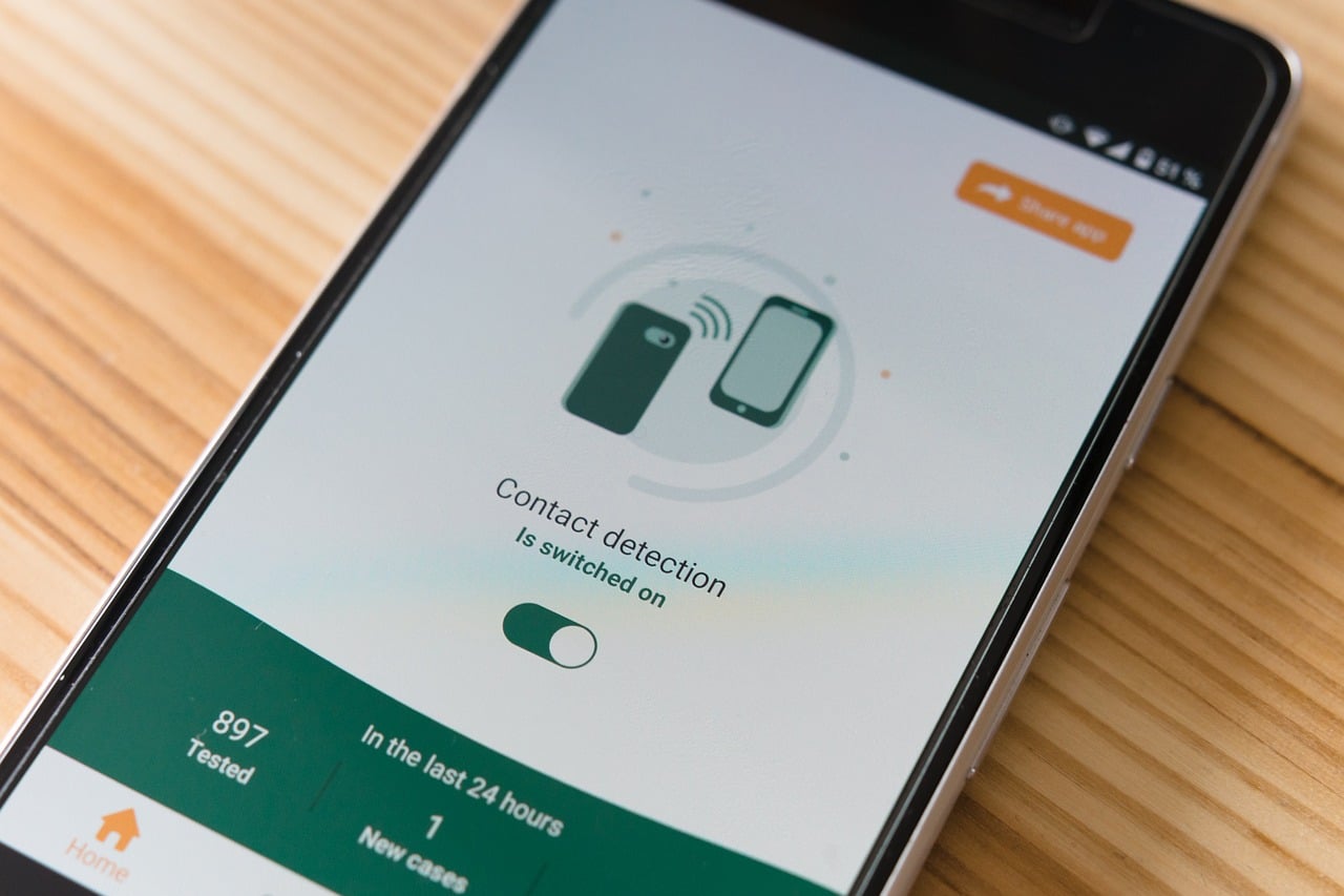
The cornerstone feature of earthquake apps is the early warning notification system. Depending on your distance from the epicenter, you might receive alerts anywhere from a few seconds to over a minute before strong shaking arrives. While seconds may not sound like much, research shows that even 5-10 seconds of warning dramatically reduces casualties and injuries.
These alerts typically include vital information such as estimated magnitude, distance from your location, expected intensity of shaking, and countdown timers showing when tremors will arrive. Push notifications work even when your phone is in sleep mode, ensuring you’re alerted regardless of what you’re doing.
🗺️ Interactive Earthquake Maps
Visual mapping features display recent seismic activity globally or filtered by region. Users can see earthquake locations, magnitudes, depths, and timestamps at a glance. Interactive maps often include heat zones showing areas of frequent activity and historical data revealing long-term seismic patterns.
These maps serve educational purposes as well, helping users understand plate tectonics and why certain regions experience more earthquakes. Watching the Pacific Ring of Fire light up with daily tremors provides powerful context for earthquake preparedness.
📊 Customizable Alert Settings
Not every minor tremor deserves a notification at 3 AM. Quality earthquake apps allow users to customize alert thresholds based on magnitude, distance, and intensity. You might choose to receive alerts only for earthquakes above magnitude 4.0 within 100 kilometers of your location, while still having access to global data when you check the app manually.
Advanced settings include quiet hours, different notification sounds for various severity levels, and the option to receive alerts for specific regions beyond your current location. This proves valuable for people with family in other seismically active areas or businesses with distributed operations.
🛡️ Why Everyone in Earthquake Zones Needs These Apps
The question isn’t whether earthquake detection apps are useful, but rather how quickly you can install one. For residents of California, Japan, Chile, Indonesia, Turkey, and dozens of other seismically active regions, these apps have become as essential as weather applications.
Traditional warning systems rely on sirens, television broadcasts, and radio announcements that might not reach people immediately. Your smartphone, however, is almost always within arm’s reach. This ubiquity makes mobile apps the most effective mass notification system ever created for earthquake warnings.
💪 Empowering Individual Preparedness
Beyond immediate alerts, these apps educate users about earthquake safety. Many include preparedness checklists, survival guides, and instructions for creating emergency kits. Some feature shake intensity estimators that help users understand what different magnitudes actually feel like and how to respond appropriately.
The psychological benefit shouldn’t be underestimated either. Living in earthquake country creates constant low-level anxiety for many people. Having a reliable detection system provides peace of mind and a sense of control over an otherwise unpredictable natural hazard.
🏘️ Building Community Resilience
When entire communities adopt earthquake apps, collective safety improves dramatically. Schools can implement automated lockdown procedures triggered by alerts. Hospitals receive warnings to pause sensitive procedures. Transportation systems can slow trains and prevent new vehicles from entering tunnels or bridges.
The crowdsourcing aspect also strengthens the detection network itself. More users mean more data points, creating denser coverage and faster detection, particularly in developing regions lacking extensive professional seismometer networks.
🎯 Choosing the Right Earthquake Detection App
Not all earthquake apps are created equal. The market offers dozens of options ranging from simple notification services to comprehensive seismological platforms. Selecting the right app depends on your specific needs, location, and desired features.
✅ Essential Criteria for Selection
When evaluating earthquake detection apps, prioritize those that source data from reputable seismological organizations. Apps connected to government geological surveys, university research networks, or international monitoring agencies provide the most accurate and timely information.
User interface matters significantly during emergencies. The best apps display critical information instantly without requiring navigation through multiple screens. Clear visual indicators, intuitive icons, and readable text sizes ensure usability when adrenaline is pumping and every second counts.
Battery consumption represents another crucial consideration. Apps that constantly run sensors and location services can drain batteries quickly. Look for options with optimized power management that balance detection capability with reasonable battery usage.
🌟 Top Features to Look For
- Multi-source data integration: Apps pulling from multiple seismological networks provide more comprehensive coverage and cross-verification
- Offline functionality: Basic features should work without internet connectivity since networks often fail during major earthquakes
- Historical data access: Ability to review past earthquakes helps users understand patterns and risks in their area
- Emergency contacts: Quick-dial features for contacting family, friends, or emergency services during disasters
- Tsunami warnings: For coastal residents, integrated tsunami alerts based on undersea earthquakes are critical
- Multiple language support: Particularly important in diverse communities or while traveling internationally
- Apple Watch and Android Wear integration: Wrist notifications provide even faster alerts than phone-only apps
📈 The Growing Accuracy of Mobile Earthquake Detection
Skeptics initially questioned whether smartphones could meaningfully contribute to earthquake detection, but recent years have validated the technology impressively. Studies from UC Berkeley, Stanford, and other leading institutions demonstrate that crowdsourced smartphone data can match or even exceed traditional networks in certain scenarios.
The sheer density of smartphones in urban areas creates detection networks far denser than could ever be achieved with traditional seismometers. In cities like Los Angeles or Tokyo with millions of smartphones, the detection grid includes thousands of sensors per square kilometer, enabling unprecedented precision in locating earthquake epicenters and measuring ground motion.
🔬 Scientific Validation and Research Support
Major earthquake detection apps now collaborate directly with research institutions and government agencies. The MyShake app, developed by UC Berkeley, feeds data directly into seismological research. Similar partnerships exist worldwide, creating symbiotic relationships where users gain early warnings while scientists gain valuable data.
Recent earthquakes in Mexico, Japan, and Greece demonstrated the system’s real-world effectiveness, with app users receiving alerts 10-90 seconds before strong shaking arrived. Post-event surveys showed that warned individuals were significantly more likely to take protective actions and less likely to suffer injuries compared to those without warnings.
🌐 Global Adoption and Regional Variations
Earthquake detection apps have achieved varying adoption rates worldwide, often correlating with both seismic risk and smartphone penetration. Japan leads in adoption, with government-endorsed systems reaching over 80% of smartphone users. California, Mexico, Chile, and New Zealand also show strong uptake.
Regional differences influence app features and priorities. Japanese apps emphasize train and elevator safety, given the nation’s extensive public transportation networks. Chilean apps focus heavily on tsunami warnings due to the country’s vulnerable coastline. Turkish apps increasingly incorporate building safety ratings following devastating earthquakes in recent years.
🚀 Future Developments on the Horizon
The next generation of earthquake detection apps will incorporate artificial intelligence more extensively, improving prediction accuracy and reducing false alarms. Integration with smart home systems will enable automated responses like opening garage doors for quick evacuation, shutting off gas lines, and unlocking doors to prevent people from becoming trapped.
Augmented reality features may soon guide users to the nearest safety zones during earthquakes, overlaying directional arrows and hazard warnings on camera views. Integration with vehicle systems could alert drivers and even assist with safe stopping procedures during significant tremors.
💡 Maximizing Safety Through Proper App Usage
Installing an earthquake detection app represents only the first step. Proper configuration and regular testing ensure maximum effectiveness when disaster strikes. Most experts recommend conducting monthly drills where family members practice responding to app alerts.
Keep your phone charged and accessible, particularly overnight when many damaging earthquakes occur. Consider keeping a charging cable and portable battery pack in your earthquake kit. Enable all necessary permissions for location, notifications, and sensor access so the app functions properly.
📝 Creating an Emergency Response Plan
Pair your earthquake app with a comprehensive emergency plan. Identify safe spots in each room where you spend time, whether under sturdy tables, in reinforced doorways, or away from windows. Practice “Drop, Cover, and Hold On” techniques so they become automatic responses.
Establish communication protocols with family members. Since phone networks often fail during major earthquakes, designate an out-of-state contact person everyone can reach via text when local calling becomes impossible. Some earthquake apps include family tracking features showing loved ones’ locations and safety status.
🔐 Privacy and Data Security Considerations
Earthquake detection apps require access to sensitive smartphone sensors and often your location. Reputable apps clearly explain what data they collect and how it’s used. Most anonymize sensor data before uploading it to detection networks, protecting user privacy while contributing to collective safety.
Review privacy policies carefully and choose apps from established developers with transparent data practices. Avoid apps requesting unnecessary permissions unrelated to earthquake detection. Leading apps are often open-source, allowing independent security experts to verify their code and data handling practices.
🎓 Educational Value Beyond Emergency Alerts
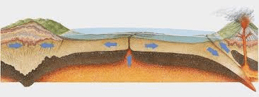
These apps serve as powerful educational tools, transforming abstract geological concepts into tangible, real-time experiences. Students can observe plate tectonics in action, tracking earthquake patterns along fault lines and subduction zones. Teachers worldwide incorporate earthquake apps into earth science curricula, making seismology accessible and engaging.
The ability to feel a minor tremor and immediately check the app to see its magnitude, location, and depth creates powerful learning moments. Users develop intuitive understanding of earthquake scales, recognizing what magnitude 3.5 versus 5.5 actually feels like and how depth affects intensity
✨ Taking Action Today for Tomorrow’s Safety
Every day without an earthquake detection app is a day of unnecessary risk for anyone living in seismically active regions. The technology exists, it’s proven effective, and in most cases, it’s completely free. Installation takes minutes, while the potential safety benefits last a lifetime.
Beyond personal safety, widespread adoption strengthens the entire detection network. Your phone becomes part of a global early warning system protecting millions. The data you anonymously contribute helps scientists better understand earthquakes and potentially save lives thousands of miles away.
Don’t wait until the next earthquake to take action. Download a reputable earthquake detection app today, configure your alert preferences, and share the information with friends and family. In those critical seconds when the ground begins to shake, you’ll be grateful for the warning these remarkable apps provide. Technology cannot prevent earthquakes, but it can absolutely help us survive them with greater safety and confidence.